Laser Scanning Solutions
A Scanning Solution For Everyone

In the field
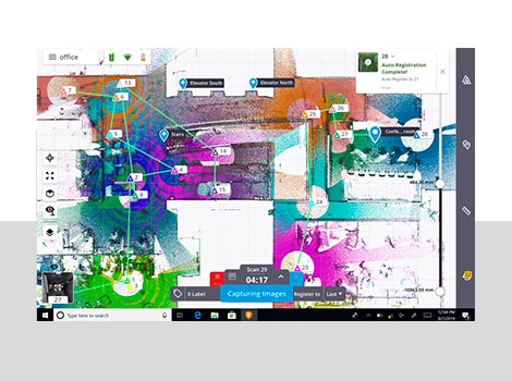
The Trimble X7 solution is fully integrated with the new Trimble Perspective software specifically designed for in-field control and complete registration. The combination enables scans and images to be captured, fully registered together, refined, controlled and exported to a variety of established data format for Trimble and non-Trimble software suites.
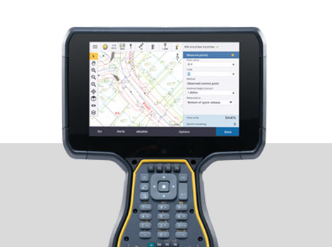
Combined with Trimble Access field software, the SX12 efficiently and reliably collects the most complete datasets from the field. Trimble Access keeps things simple by allowing you to combine optical, scanning, GNSS data and images all in one job.
- Measure the desired level of detail
- Integrated survey workflows
- Efficient data management within any geodetic coordinate system library

In the Office
Trimble Business Center lets you fully integrate scan data into your projects using the familiar workflows of the market leading survey office software. Enhanced point cloud management, automated extraction and interoperability, and CAD and GIS packages producing deliverables to satisfy your toughest client demands.
Trimble RealWorks® is state-of-the-art office software for registering, visualizing, exploring and manipulating as-built or scene point cloud data collected with virtually any laser scanner. Efficiently manage, process, and analyze large data sets with confidence and transform them into compelling 2D and 3D deliverables. RealWorks is easy to use, as the interface guides you through each tool step by step to ensure you reach your objectives.

With your customer
Import profiles and geometric primitives from a CAD design file or export graphic files in .dxf or .dgn format. Print inspection results using the RealWorks integrated print-out interface to share and deliver the detailed and insightful information your clients need.
- Export data for use in popular CAD software
- Use Publisher to freely share projects via Internet Explorer and Trimble Scan Explorer
- Use Trimble Clarity, a browser-based viewer for point cloud and 3D model data, to share projects and progress updates to your team or your clients, allowing them to interact with the data without having to have 3rd party software installed on their computer.