Trimble Access Rail module Stakeout
Trimble Access Rail module Stakeout
Software for alignment-based field measurements. Based on the measurements made by Trimble total stations or Trimble GNSS receivers, differences between actual and design according to the track alignment are displayed directly in the field. Target values for chainage, lateral distance and height offset can be entered manually or selected from a list. The calculation can be done horizontally or in a canted (superelevated) system. All points as well as the track alignment with its track main points are displayed in the interactive map.
The track alignment is described by the horizontal alignment, vertical alignment, cant (superelevation) alignment, and optionally a chainage line. In addition to common track alignment elements, special transition curves as well as track shears are also supported.

- Digital data flow from the office to the field
- Alignment-based measurement with real-time information in the field
- Calculation either horizontally or in a canted (superelevated) system
- Support of all common track alignment elements
- Total station and GNSS-based data capture for reliable positioning
- Data check at the office in advance optimizes work in the field
- For all Trimble Access control units
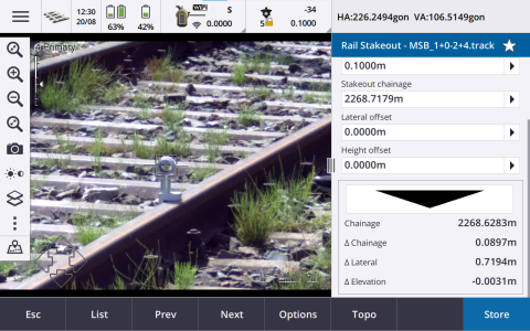
- Stakeout of track design position with lateral marking points
- Stakeout of switches
- Stakeout of platform edges and other objects relative to track alignment
- Control measurements
- Setting up short sections of track (low daily output rates)
- Checking of distances
- Preservation of evidence
- Data capture for the creation of stakeout reports